FAQs
3/1/2026
Contents


Selecting a robot lawn mower often leads to a key technology question: RTK or LiDAR? These are two of the most advanced navigation systems available, each promising a wire-free and intelligent mowing experience, but they work in fundamentally different ways. Understanding how RTK uses satellite signals and how LiDAR scans with lasers is the first step to figuring out which one will be the perfect, reliable partner for your unique yard. Let's break down how each system operates, where they excel, and where they might face challenges.
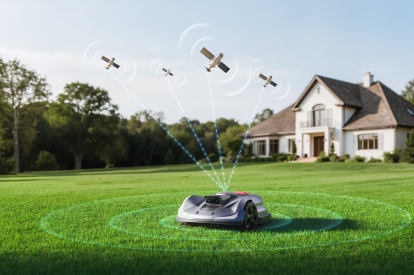
RTK stands for Real-Time Kinematic, and it represents a significant leap forward from basic GPS navigation. Think of it as giving your mower access to a hyper-accurate, real-time map of your property.
RTK (Real-Time Kinematic) achieves centimeter-level accuracy through differential correction. It uses a stationary base station in your yard and a rover on the mower. The base station calculates satellite signal errors from its known position and sends corrections to the mower via radio. This allows the mower to pinpoint its location within 1-3 cm, enabling precise virtual boundaries.
A more advanced variant is Network RTK (NRTK), which connects to a network of permanent reference stations rather than a single, private base. This approach eliminates a single point of failure, provides redundancy for network-level quality control, and enhances overall correction accuracy, availability, and reliability. However, it depends on strong cellular signal coverage in your yard.
For detailed guidance on optimizing signal strength and troubleshooting common issues, please read What Is RTK Technology? A Smarter Way to Mow Your Lawn.
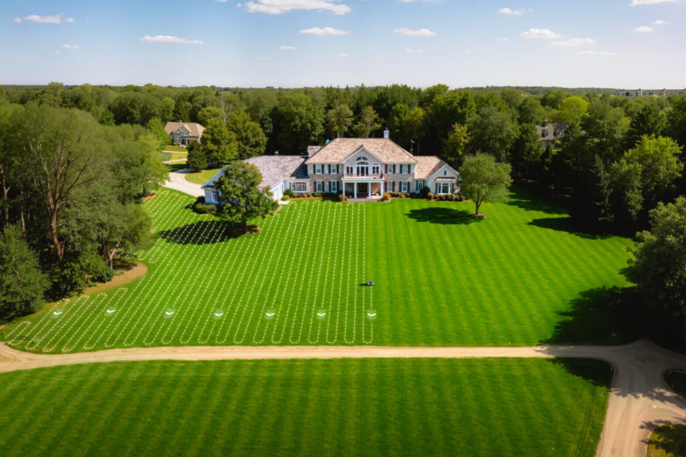
Efficient Path Planning: Precise location data enables structured mowing patterns instead of random movement, reducing mowing time and energy consumption. In models such as the Sunseeker Elite X Gen 2 Series powered by Network RTK and VSLAM, this translates into faster job completion and consistently uniform visual results across the entire lawn.
Precise Edge Cutting: High-accuracy RTK positioning allows the mower to follow boundaries with exceptional precision, trimming cleanly along edges, paths, and borders. This minimizes uncut strips and reduces the need for manual touch-ups after mowing.
Consistent Boundary Control: Virtual boundaries remain stable over time and are not affected by grass growth or soil movement. Adjustments can be made digitally without reinstalling physical wires.
Ideal for Large Lawns: RTK performs especially well in open, expansive areas where satellite signals remain stable. This makes it a strong choice for large residential properties and commercial landscapes.
Sunseeker Elite X Gen 2 Series planning path intelligently
Signal Dependency: RTK relies on stable satellite and correction signals to maintain accuracy. Performance may be affected in areas with heavy tree cover, tall buildings, or narrow passages.
Higher Cost: RTK robot mowers typically come at a higher upfront price due to advanced positioning hardware and base station requirements. This can be a barrier for smaller lawns or budget-conscious users.
Setup Complexity: Initial installation and calibration can be more involved compared to simpler navigation systems. Proper base station placement is critical to achieving reliable performance, though it’s worth noting that NRTK systems remove the need for a local base station.
LiDAR, which stands for Light Detection and Ranging, takes a completely different approach. Instead of looking up to the sky, it uses lasers to build a detailed map of its immediate surroundings.
A LiDAR-equipped mower has a rotating sensor on top that emits rapid pulses of laser light. It measures the time it takes for each pulse to bounce back from objects like trees, fences, or garden beds. By compiling millions of these distance measurements, the mower constructs a highly detailed 2D or 3D point-cloud map of your garden.
In advanced models like the Sunseeker Elite X4, a 360° 3D LiDAR with an effective resolution of 172 lines spins at 6,000 rpm, scanning a 360° horizontal and 70° vertical field of view and generating up to 210,000 points per second. This extremely dense point cloud enables richer, real-time environmental perception, allowing the mower to localize itself precisely and navigate confidently, entirely independent of satellite signals.
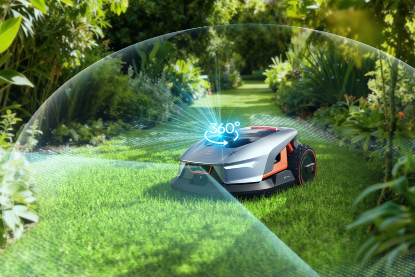
Sunseeker Elite X4 equipped with a 360° 3D LiDAR
Highly Effective in Complex Layouts: LiDAR-based navigation adapts well to irregular lawn shapes, multiple zones, and tight corridors. Real-time mapping allows the mower to navigate confidently through complex garden layouts without losing accuracy.
Advanced Obstacle Detection: LiDAR excels at identifying objects ahead of the mower, supporting smooth avoidance and safer operation around furniture, pets, and garden features.
Stable Performance in Shaded Areas: Unlike RTK, LiDAR is not affected by tree cover or nearby buildings. Consistent navigation is maintained even in narrow passages, courtyards, or gardens with dense landscaping.
Quick Setup: Most LiDAR-based robot mowers require minimal installation and no base station. Mapping is typically completed through an app, enabling faster deployment and easier adjustments.
Higher Hardware Cost: LiDAR is typically the most expensive navigation technology used in consumer robot mowers. Advanced sensors and processing hardware significantly increase the upfront price.
Weather Sensitivity: LiDAR accuracy can be reduced in extreme weather conditions such as heavy rain, fog, or dust. Although most systems compensate well, performance may temporarily decline.
Poor Orientation in Open Lawns: In large, open, and featureless yards, LiDAR systems may take longer to build an initial map. Compared to RTK, which relies on precise GPS coordinates, initial positioning can be less immediate.
To help you visualize the choice, here is a direct comparison of how these two technologies stack up across key practical dimensions.
|
Feature |
RTK Robot Mowers |
LiDAR Robot Mowers |
|
Positioning Method |
Uses satellite-based RTK correction signals for absolute positioning |
Uses laser scanning to build a real-time 3D map of the environment |
|
Navigation Accuracy |
Centimeter-level global accuracy across open areas |
High local accuracy based on environmental mapping |
|
Edge Cutting Precision |
Excellent, ideal for clean and well-defined boundaries |
Good, but may be slightly less precise on large open edges |
|
Performance Under Trees |
May be affected by dense tree cover or tall structures |
Performs reliably under trees and in shaded areas |
|
Suitability for Lawn Size |
Best for large, open lawns and commercial spaces |
Well-suited for small to medium lawns and complex layouts |
|
Setup Requirements |
Requires base station or NRTK support for optimal accuracy |
Typically no base station required, quick app-based setup |
|
Obstacle Detection |
Relies more on predefined paths and additional sensors |
Strong real-time obstacle detection via LiDAR mapping |
|
Weather Sensitivity |
Heavy rain or thick fog can weaken satellite signals |
Accuracy may decrease slightly in heavy rain or fog |
|
Cost Range |
Higher upfront cost due to advanced positioning hardware |
Mid to high cost depending on sensor configuration |
In essence, an RTK mower is like a pilot following a supremely accurate flight plan, relying on clear communication with satellites. A LiDAR mower is more like a self-driving car, using its own sensors to perceive and react to the world in real-time. One is optimized for open-space efficiency, the other for complex-environment intelligence.
The best technology is the one that aligns with the specific challenges and layout of your property. A simple self-assessment will point you in the right direction.
Take a critical look at your lawn. Key factors include its total size, how much is under tree cover versus open sky, the number and type of permanent obstacles (gardens, trees, sheds), and the presence of temporary obstacles like children's toys. Also, note the severity of any slopes.
1. Large, Open Lawns: RTK Navigation
RTK excels in wide, unobstructed areas where satellite signals remain stable. It delivers centimeter-level accuracy, making it ideal for large properties that prioritize efficiency, straight mowing lines, and precise edging.
2. Complex Residential Gardens: LiDAR + Vision AI
Gardens with narrow passages, curved borders, and multiple sections benefit from LiDAR and vision-based navigation. Real-time environmental mapping allows smooth adaptation to changing layouts and obstacles.
3. Tree-Covered or Shaded Lawns: LiDAR or Vision-Based Navigation
In areas with heavy tree cover or tall hedges, satellite-dependent systems may struggle. LiDAR and camera-based systems maintain consistent performance without relying on GNSS signals.
4. Simple, Small Lawns:Boundary Wire Navigation
Traditional boundary wire systems are cost-effective and work well in straightforward, compact lawns. Easy to install and sufficient where precision and advanced mapping aren’t priorities.
Your budget is a practical and important constraint. If funds are limited, a basic model without RTK or LiDAR can handle everyday mowing needs. With a higher budget, RTK mowers offer a well-balanced mix of performance and value, especially for large lawns. LiDAR mowers tend to sit at a higher price point, appealing to users who prioritize top-tier obstacle avoidance.
Choosing between RTK and LiDAR robot mowers ultimately comes down to your lawn’s size, layout, and priorities. RTK excels in large, open spaces where absolute precision and efficient coverage matter most, while LiDAR shines in complex, obstacle-rich gardens that demand adaptability and advanced awareness. Budget, installation preferences, and long-term ease of use should all factor into the decision.
Sunseeker Elite Robotics offers models equipped with both RTK or LiDAR technologies, each seamlessly integrated with Vision AI, giving you the flexibility to choose a solution tailored to your yard. With the right match, robotic mowing becomes a truly hands-off, reliable part of lawn care.
For small lawns, RTK is usually unnecessary, as its high-precision positioning is designed for large, open areas. LiDAR or Vision AI–based systems are often a better fit, offering reliable navigation and obstacle avoidance in tighter or more complex spaces.
RTK performance may decline under dense tree cover due to weaker satellite signals. LiDAR-based mowers handle shaded areas more reliably, as they rely on environmental scanning rather than GPS, making them better suited for tree-heavy or enclosed gardens.
Vision AI enhances obstacle recognition and decision-making by identifying objects in real time. When combined with RTK or LiDAR, it improves safety, reduces unnecessary stops, and enables smoother navigation around pets, furniture, and garden features.